

Urban Congestion Challenges


How MobilityIQ Works?
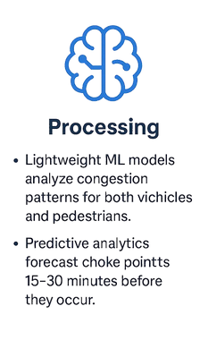
MobilityIQ leverages video analytics and machine learning to monitor and manage both vehicular and pedestrian congestion in real time. By integrating with city ICCCs (Integrated Command and Control Centers) and existing CCTV networks, it provides actionable insights for seamless crowd and traffic management.

Features


Density
HeatMap
Wait
Time
Dashboard + Mobile App
Public
Privacy
Anomaly Detection
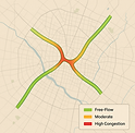
Displays real-time Crowd density (people/sq.m) and Vehicular congestion (speed/occupancy).
Identifies estimated wait times on route, intersections and crowd attracting areas
Flags sudden dispersions (stampede risks) or unusual traffic jams caused by accidents.
Monitoring and alerts via a centralized dashboard.
Resource allocation suggestions
Anonymized identification of individuals and vehicles
Usecases

-
Identify high-density vehicular zones during rush hours or special events (e.g., rallies).
-
Suggest alternate routes using predictive analytics to alleviate bottlenecks.

-
Monitor crowd density during large-scale events to prevent stampedes.
-
Predict choke points along procession routes using historical data combined with real-time video feeds.

-
Optimize passenger flow at metro stations by detecting overcrowded platforms or ticket counters.
-
Provide data-driven scheduling adjustments to reduce peak-hour congestion.

-
Manage crowds at concerts, sporting events, or rallies by identifying high-risk zones early.
-
Facilitate evacuation plans during emergencies